Interagency Access Pass
Mammoth Ski Trails
Get real time grooming updates, offline trail maps, and trail conditions with 
MAMMOTH HOT SPRINGS SKI TRAILS
Shuttle services are available from Mammoth Hot Springs Hotel to the Swan Lake and Indian Creek areas on a pre-arranged basis only. Tickets must be purchased in advance at the front desk in the ski shop. Arrangements need to be made for pickup ahead of time. If you miss your shuttle pickup, notify the front desk upon your return to prevent initiation of a search. For more info on specific trails, see the map and descriptions below or download trail descriptions and trail map. For up to date trail conditions call (307-344-5699) or stop by our ski shop.
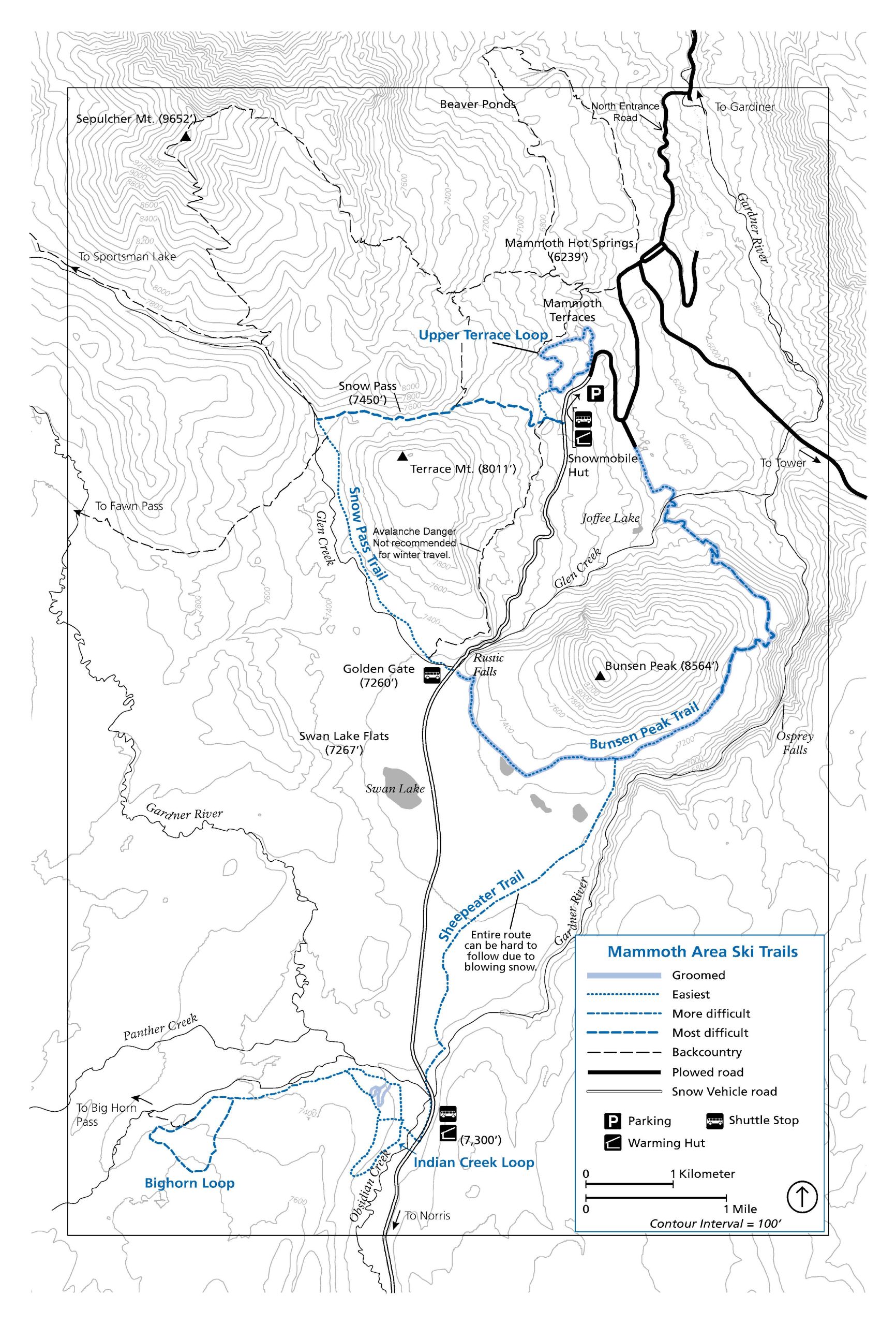
SNOW PASS TRAIL
4.2 miles (6.76 km), to intersection with groomed road or Bunsen Peak Trail, most difficult
Begin 0.4 miles (0.6 km) south of the Upper Terrace parking area on the west side of the Mammoth-Norris road or a short connector trail joins from the upper end of the Upper Terrace Loop. The heavily forested trail ascends 700 feet in 1.5 miles (213 m in 2.4 km) through a series of very steep grades along the trail to Snow Pass. From Snow Pass the trail continues 0.5 miles (0.8 km) down over rolling terrain to a trail junction where the ski route turns left (south) and follows Glen Creek over fairly level terrain for 2.2 miles (3.5 km), returning to the road just south of Rustic Falls. From here, you can either continue across the road to the Bunsen Peak Road (see description) or turn left and ski down the main road back to the Upper Terrace parking lot (this adds 2.6 miles (4.2 km) to the trip).
BUNSEN PEAK TRAIL (GROOMED)
6 miles (9.6 km), most difficult
Begin on the Mammoth-Norris road, just south of Rustic Falls and across from the upper end of the Snow Pass Trail. The upper 3 miles (4.8 km) are mostly level and suitable for all levels of skiing ability. On the northeast side of Bunsen Peak, the road becomes steep and winding, dropping 960 feet in 2.5 miles (292 m in 4 km) to Glen Creek. Caution: some curves have steep drop-offs and can be hazardous when icy. From Glen Creek the trail climbs 0.5 miles (0.8 km) to a plowed road in an employee housing area YCC Facility 0.8 miles (1.3 km) below the Upper Terrace parking area and 1.3 miles (2.1 km) above Mammoth. This trail provides fine views of the Gallatin Mountains and the Gardner River Canyon.
INDIAN CREEK LOOP
2.2 miles (3.5 km), easiest
Begin at the Indian Creek Warming Hut and follow the campground road north, then west through the campground along Indian Creek. About 0.5 miles (0.8 km) west of the campground, the trail turns left (south) through gently rolling, timbered terrain, past the cutoff and on toward Obsidian Creek where it follows an old wagon road north back to the hut. This trail is mostly very gentle. It offers glimpses of the Gallatin Range to the west and travels through the forest.
BIGHORN LOOP
5.5 miles (8.85 km), more difficult to most difficult
Begin at the Indian Creek Warming Hut and follow the Indian Creek Loop for the first mile. Continue west, making a loop through rolling terrain with outstanding views of the Gallatin Mountains, Gardner’s Hole, and the surrounding country. After completing the loop, return to the Indian Creek Warming Hut by the same route. There is also a cut-off which heads west from the Indian Creek Hut and the Indian Creek Loop 0.12 miles (0.2 km) from the hut.
SHEEPEATER TRAIL
5.2 miles (8.36 km), more difficult due to snow conditions
Begin at the Indian Creek Warming Hut, ski along the road 0.5 miles (0.8 km) north to Sheepeater Cliffs picnic area. The trail skirts the east side of Swan Lake Flats through interspersed forest and meadow with views of the Gallatin Range and the Gardner River Canyon for 3.1 miles. The trail connects with the Bunsen Peak Trail and continues approximately 1.6 miles (2.5 km) west to the Mammoth-Norris road.
UPPER TERRACE LOOP TRAIL (GROOMED)
1.5 miles (2.4 km), more difficult
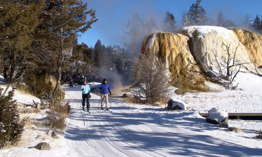
This loop begins at the Upper Terrace parking area. It is easiest if skied beginning to the left (clockwise). A moderate climb leads to views of hot springs, terraces, and the surrounding mountains. At the top of the climb, a trail veers off to the southwest, which connects with the Snow Pass Trail. The Terrace Loop Trail descends past more hot springs before completing the circuit. Since snow depths here are less than in the mountains above, wintering elk and deer are occasionally sighted. Caution: please stay on the groomed trail – shortcutting or cross country travel can damage the fragile features of the thermal areas along this trail and is prohibited
Caution: Do not attempt to ski any backcountry trails without good topographical maps and first inquiring about trail conditions. Backcountry trails are marked on this map with dashed black lines. Many of them are difficult to find and follow as they are not well-marked for winter travel and have not necessarily been skied recently. Many go through avalanche-prone areas that are not marked.