Interagency Access Pass
Old Faithful Ski Trails
Get real time grooming updates, offline trail maps, and trail conditions with 
OLD FAITHFUL AREA SKI TRAILS
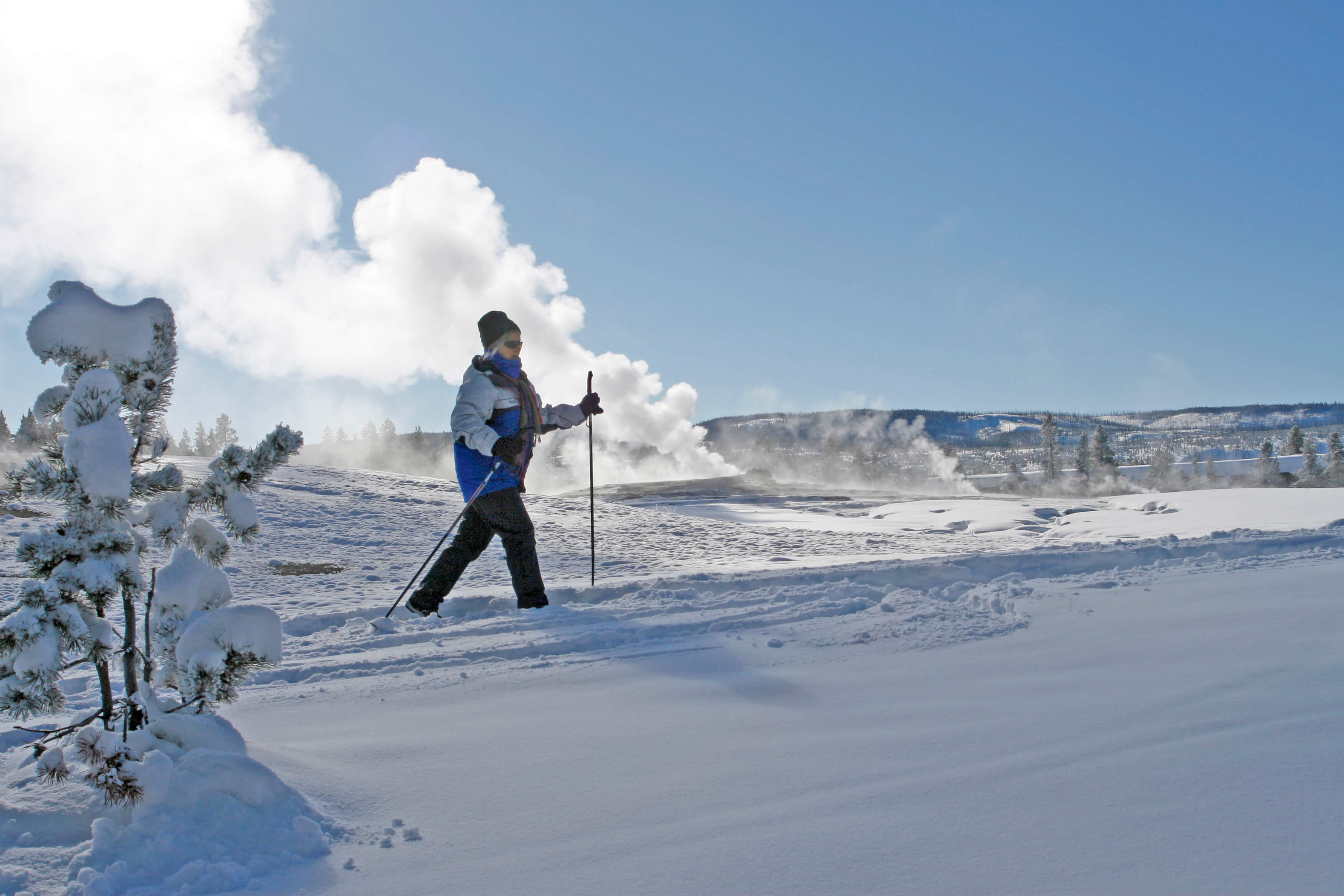
Old Faithful is a skier’s paradise with trails that glide along hot springs, geysers, and wildlife. A number of trails are machine groomed and ideal for beginners. Near the Snow Lodge there are a few practice loops that follow summer roads. In addition to the Upper Geyser Basin Trail, the ski shop to morning glory is groomed (but often has bare patches due to thermal heat). The ski trail maps below provide a wide view of all Old Faithful Area ski trails and a Local Area view of trails that are closest to the Old Faithful Village. Download the Old Faithful area trail map and descriptions and the Old Faithful local area trail map and descriptions. For up to date trail conditions stop by our ski shop.
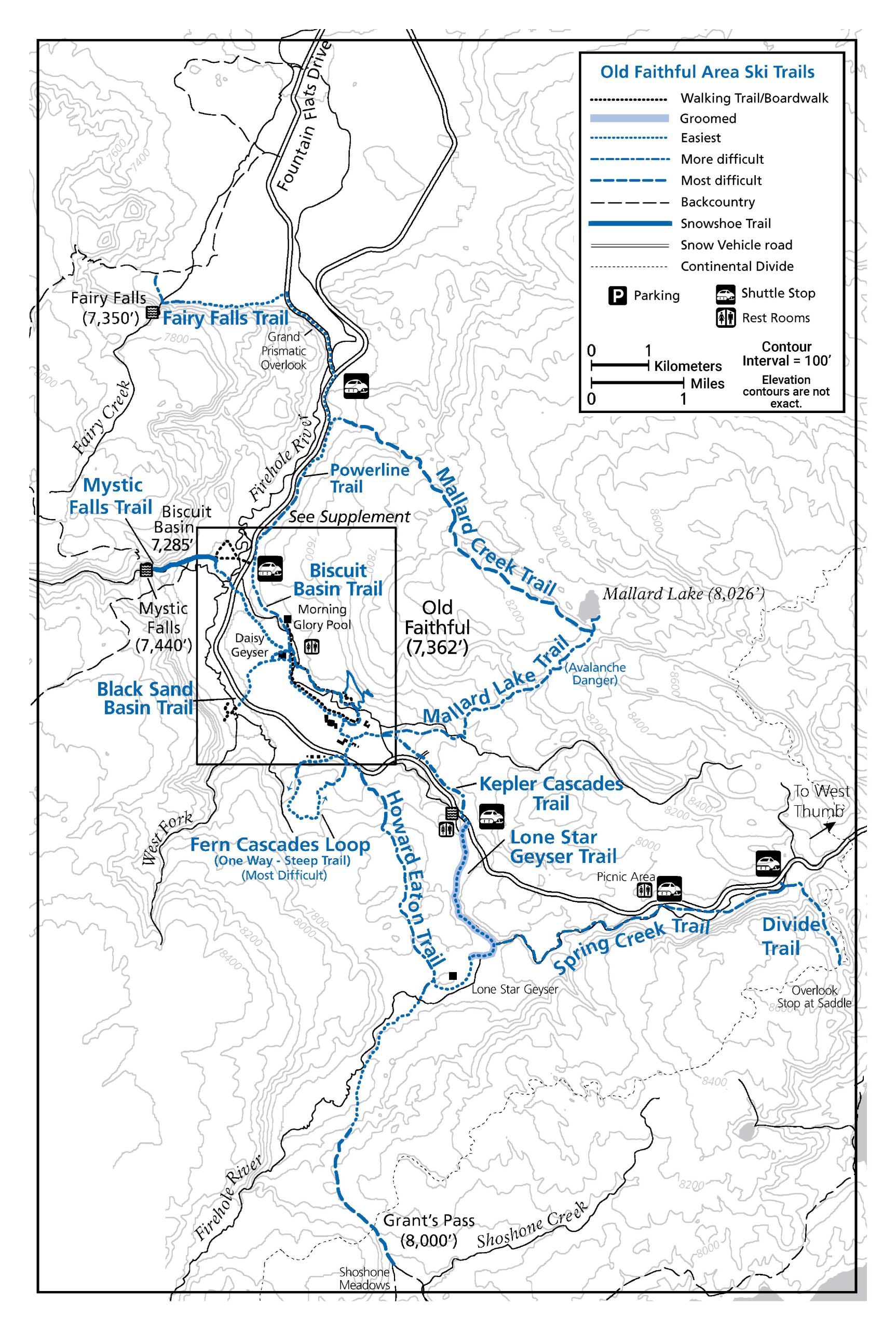
LONE STAR GEYSER TRAIL (GROOMED)
6.8 miles (10.9 km) round trip with ski drop.
8.5 miles (13.7 km) round trip from Old Faithful Snow Lodge, machine-groomed part of the way.
Beginning at the snow vehicle road above Kepler Cascades, the trail follows a service road through the forest and along the Firehole River to Lone Star Geyser. Lone Star Geyser erupts about every 3 hours with activity lasting approximately 20 minutes. Choose the snow vehicle road all of the way back to the lodge for easiest return. Choose Kepler Cascades trail on return trip for a more difficult trail with hills. For a most difficult return route, take the Howard Eaton Trail (below).
HOWARD EATON TRAIL
3.5 miles (5.6 km) one way to Lone Star Geyser, most difficult, skier-tracked
Attempt this steep trail only if you have excellent speed control and turning skills. Most of the trail is through a narrow gap in a dense forest and can be very dangerous. The trail starts at the Bear Den Ski Shop exit and angles towards the Snow Lodge cabin area. Then the trail passes through trees and crosses small bridges to reach the main snow vehicle road. Cross the snow vehicle road and go left at the Howard Eaton Trail sign. The trail climbs steeply for about 1.5 miles (2.4 km), then descends to Lone Star Geyser. Please yield to downhill skiers. Where the trail crosses near thermal areas, you may need to remove your skis due to lack of snow.
FAIRY FALLS TRAIL
10 miles (16.1 km) with ski drop, round trip, easiest to more difficult, skier-tracked
Ski 1.3 miles (2.1 km) on the Fountain Flats Drive, then turn left on the Fairy Falls Trail. Most of the Fairy Falls Trail is level, but there are hills and bends in the trail near the falls. Return via the same route, then take the Powerline Trail or the snow vehicle road to Old Faithful. To reach the more difficult Powerline Trail, ski about 0.25 miles (0.4 km) south (right) along the snow vehicle road to the Mallard Creek trailhead on the left. Follow the Mallard Creek Trail and turn right at the first junction onto the Powerline Trail, which has rolling hills. The Powerline Trail leads to the Upper Geyser Basin Trail and Morning Glory Pool. Where the trail crosses near thermal areas, you may need to remove your skis due to lack of snow.
MALLARD LAKE TRAIL
3.6 miles (5.8 km) one way, more difficult, skier-tracked
Beginning near Snow Lodge, the trail follows Mallard Lake/Kepler Cascades Trail across the Firehole River bridge. At the trail junction, the trail goes left through the forest and climbs to Mallard Lake, with some steep sections and sidehills. Beware of avalanches. This trail is not recommended in very icy conditions. The Mallard Creek trail junction is approximately 0.2 miles (0.3 km) before the lake. Return downhill to Old Faithful the same way.
MALLARD CREEK TRAIL
13.8 miles (22.2 km) round trip from Old Faithful, most difficult, skier-tracked (7,320’ – 8,120’, 800 ft. elevation gain/loss).
This trail branches off the Mallard Lake Trail 0.2 miles (0.3 km) before the lake. From the junction, the trail climbs steeply up switchbacks to a ridge overlooking Mallard Lake and then heads northwest for approximately 4 miles (6.4 km). The trail has many challenging turns and crosses numerous deep gullies. Sections of the trail may be hard to follow and may not be well marked. Only advanced skiers should attempt this trail. The return to Old Faithful is another 4 miles (6.4 km) over gently rolling terrain along the Powerline Trail and through the Upper Geyser Basin. NOTE: Start time for this trail should be no later than 8:00 a.m. Bring along a headlamp and let someone know where you are going.
KEPLER CASCADES TRAIL
1.7 miles (2.7 km) one way, more difficult, skier-tracked
The trail follows the Mallard Lake/Lone Star Geyser Trail across the Firehole River bridge. At the trail junction, the trail goes to the right. In approximately 25 yards (23 m), the trail goes left and uphill through a narrow gap in the trees. Once you see the main snow vehicle road, you have the option of skiing facing traffic on the road. The road has more gradual uphill sections, while the trail has steep hills. The trail ends at the main snow vehicle road. To view the cascades, cross the road to the large pullout. Go past Kepler Cascades pullout to find the beginning of the Lone Star Trail.
SPRING CREEK TRAIL
8.3 miles (13.4 km) returning via Kepler Trail, most difficult, skier-tracked. Snowcoach drop at Divide Trailhead
The trail starts with a short uphill climb. At the junction, turn right and go down a steep narrow trail through dense forest. Excellent speed control and turning skills are required.
6.6 miles (10.6 km) returning via Kepler Trail, more difficult, Snowcoach drop at the Spring Creek Picnic Area
The trail traverses rolling hills, level terrain, forests, canyons, and many small bridges over Spring Creek. There are additional areas
where you may need to sidestep up and also sidestep down a steep hill. Please do not take your skis off as it creates a hazard for other skiers. The trail ends at the Lone Star Geyser Trail. Turn right to return to Old Faithful via the snow vehicle road or Kepler Cascades Trail. Turn left to reach Lone Star Geyser. The Howard Eaton Trail starts immediately beyond Lone Star Geyser.
DIVIDE TRAIL
2.5 miles (4.0 km) round trip from Spring Creek Trail Junction, more difficult, skier-tracked
The trail climbs up to a saddle on the Continental Divide. On a clear day, you may have views of Shoshone Lake and Mt. Sheridan. Return to Old Faithful via the Spring Creek Trail.
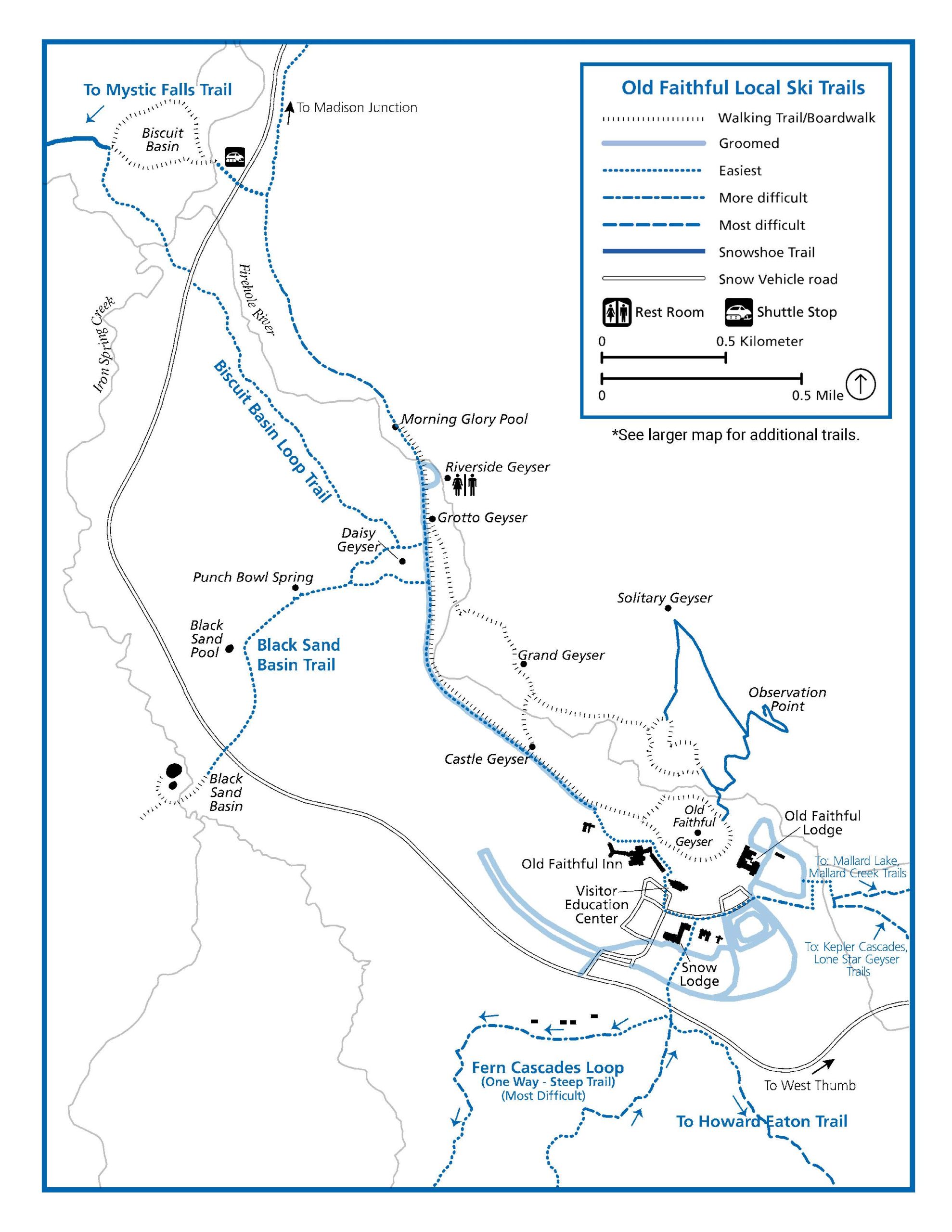
BLACK SAND BASIN TRAIL
4 miles (6.4 km) round trip, easiest, machine groomed part of the way.
Begin in front of the Old Faithful Inn and take the Upper Geyser Basin Trail past Castle Geyser. Turn left onto the skier-tracked trail to Daisy Geyser, stay to the left and continue to the snow vehicle road. Black Sand Basin is across the snow vehicle road.
BISCUIT BASIN LOOP TRAIL
5 miles (8 km) round trip, easy to more difficult, machine-groomed part of the way.
Starting at Old Faithful, follow the Upper Geyser Basin Trail past Morning Glory Pool on a skier tracked trail that leads to the junction with the Powerline Trail. Proceed left to the snow vehicle road opposite Biscuit Basin (or take a shuttle to this point). There are steep snow-covered sections of the trail beyond Morning Glory Pool, please do not remove your skis. You can side-step this hill with skis on. Continue across the road to Biscuit Basin. Then, to return on the Daisy Geyser Trail, turn right on the snow vehicle road, cross the bridge and take the Daisy Geyser Trail on the left side of the road. Follow this trail to the Upper Geyser Basin Trail. Turn right to return to Old Faithful.
MYSTIC FALLS TRAIL
3 miles (4.8 km) round trip starting and ending at Biscuit Basin.
This is a narrow and rolling trail (+/- 500ft.) making it a perfect destination on snowshoes. The trail follows the Little Firehole River to the 70 foot waterfall. It is best to follow the main trail and not climb to the overlook. Often the trail has bare patches due to thermals and small side creeks. Skiers – there is not room for 2 sets of tracks, so you will be skiing in a snowshoe trail.
FERN CASCADES LOOP TRAIL
2.75 miles (4.4 km), most difficult, skier-tracked
Start at the Bear Den Ski Shop exit and angle towards the Snow Lodge cabin area. Then the trail goes through trees and crosses small bridges to reach the main snow vehicle road. The trail begins across the road. Bear right on this one-way loop and follow under the power lines. If the uphill section at the start of the trail is too steep, turn around. The trail only gets more difficult from there. The trail continues close to the bottom of the hillside, past many buildings, then curves steeply uphill through the trees. It will be necessary to
“herringbone” up steep sections. Please do not remove your skis. At the top of the hill, there is a small, easily-missed canyon on the right where the cascades are located. Do not approach the edge of the overlook when viewing the cascades. The middle section of the trail is gently rolling. At the end is a steep downhill section that requires good speed control. For downhill speed control on skis, you must have strong “snowplowing” skills in order to attempt this trail.